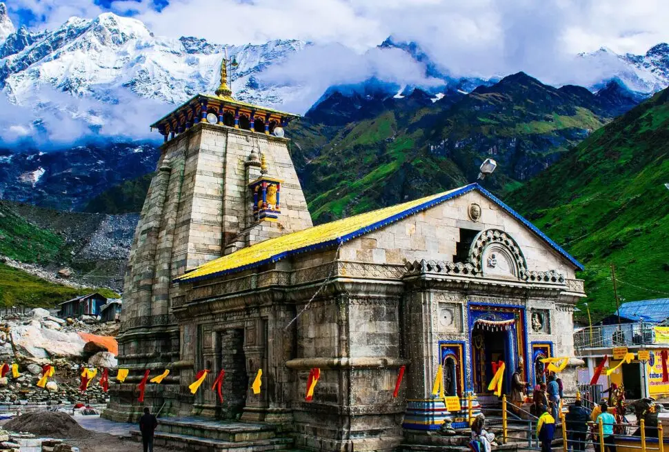
Quick answer: Kedarnath temple stands at about 3,583 metres, or about 11,755 feet, above sea level (official sources give 3,583–3,584 m). Yatris start the walk at Gaurikund, at about 1,982 m (about 6,503 ft), so the trek climbs roughly 1,600 m. Kedarnath is higher than Badrinath, Gangotri and Yamunotri, and a little lower than Tungnath.
−11°C / 4°C
−9°C / 5°C
−8°C / 6°C
Forecast estimate for this spot, not a thermometer reading at the temple; actual weather can differ. Always follow official IMD alerts. Weather data: MET Norway (CC BY 4.0), updates automatically; tap Refresh for the latest.
Facts checked November 2026.
| Height | About 3,583 m (about 11,755 ft); official sources give 3,583–3,584 m |
|---|---|
| Location | Beside the Mandakini river, Rudraprayag district |
| Trek start | Gaurikund, 1,982 m (about 6,503 ft) |
| Road stop | Sonprayag, 1,829 m (about 6,001 ft) |
| Height gain on trek | About 1,600 m from Gaurikund |
| Among the Char Dham | Highest: Kedarnath, about 3,583 m; then Yamunotri 3,293 m, Badrinath 3,133 m and Gangotri 3,100 m |
| Advisory: daily height gain | Limit to 800–1,000 m per day where you can |
Kedarnath is the highest of the four Char Dham temples in Uttarakhand. Knowing its height helps families plan the walk, pack the right clothes and look after elders. This guide gives the official heights in metres and feet, compares Kedarnath with the other dhams, and sums up what the state health advisory says about high altitude.
This page is part of our Kedarnath Yatra Guide. Planning the yatra? See our Kedarnath yatra packages.
How high is Kedarnath temple?
Kedarnath temple is at about 3,583 metres (about 11,755 feet) above sea level. Uttarakhand government pages give slightly different figures. The state heli services page says 3,583 m, and the Shri Kedarnath Dham trust page says 3,584 m (about 11,759 ft). A few other state pages round it differently, between 3,580 m and 3,586 m. These are small differences of a few metres, so “about 3,583 m” is a safe figure to remember.
The temple sits beside the Mandakini river in Rudraprayag district, with snow peaks rising behind it. Since it is above 3,000 metres, the state health advisory for high altitude applies to the Kedarnath yatra.
What is the height of the trek points?
Road vehicles stop at Sonprayag, and a shuttle takes yatris on to Gaurikund, where the walk to Kedarnath begins. Here are the heights given on official pages:
| Place | Height (metres) | Height (feet, about) |
|---|---|---|
| Sonprayag | 1,829 m | about 6,001 ft |
| Gaurikund (trek start) | 1,982 m | about 6,503 ft |
| Kedarnath temple | about 3,583 m (sources give 3,583–3,584 m) | about 11,755 ft |
From Gaurikund to the temple, the path gains about 1,600 metres. From Sonprayag, the total gain is about 1,750 metres. The Rudraprayag district rate list places Bhimbali about 6 km and Linchauli about 11 km from Gaurikund. We have not found an official height for Bhimbali or Linchauli, so we have left those out rather than guess.
For the full route, stays and walking plan, see our Kedarnath yatra guide.
Is Kedarnath higher than Badrinath, Gangotri, Yamunotri and Tungnath?
Kedarnath is the highest of the four Char Dham temples. Tungnath, one of the Panch Kedar, is higher still.
| Temple | Height (metres) | Height (feet, about) |
|---|---|---|
| Tungnath | 3,680 m | about 12,073 ft |
| Kedarnath | about 3,583 m | about 11,755 ft |
| Yamunotri | 3,293 m | about 10,804 ft |
| Badrinath | 3,133 m | about 10,279 ft |
| Gangotri | 3,100 m | about 10,171 ft |
The Char Dham heights are from the Uttarakhand registration and tourist care portal. The Tungnath height is from the Shri Kedarnath Dham trust website. Kedarnath is about 450 m higher than Badrinath. Unlike Badrinath and Gangotri, which you can reach by road, you reach Kedarnath on foot, by pony or palki, or by helicopter.
Which peaks stand behind Kedarnath temple?
Snow peaks of the Garhwal Himalaya rise behind the temple. The best known is Kedar Dome. Uttarakhand’s mountaineering portal says it “forms the backdrop to the Kedarnath temple” and lists it at 6,831 m (about 22,411 ft). The Shri Kedarnath Dham trust page gives Kedar Dome as 6,940 m, so figures vary by source. Either way, the peaks behind the temple rise more than 3,000 metres above the temple itself.
What does the altitude mean for yatris?
Above 3,000 metres, the air is thinner, so each breath carries less oxygen. The Uttarakhand health department’s advisory also mentions cold, low humidity, strong sun (UV) and low air pressure. Most healthy yatris manage well when they go slowly and give the body time to adjust.
What the official health advisory recommends
- Plan the yatra for at least 7 days, with time to adjust to altitude and planned rest points and night stays.
- Limit height gain to 800–1,000 m per day where you can. The Gaurikund–Kedarnath walk gains about 1,600 m, so walk slowly and plan your night stays with this in mind.
- Rest for 5–10 minutes for every hour of trekking.
- Before the yatra, practise breathing exercises for 5–10 minutes and walk every day.
- Drink enough fluids, preferably lukewarm, and eat nourishing food. Carry dry fruits and biscuits.
- Pack for cold, rain and sun, and check the weather before starting.
- Carry your prescribed medicines and your doctor’s contact details. The 2023 advisory also suggested carrying a pulse oximeter and a thermometer.
- Avoid smoking, alcohol and other intoxicants during the yatra.
- If you feel unwell, do not go higher. Go down and get checked at the nearest health centre before continuing.
Signs that need help straight away
The advisory asks yatris to get help at the nearest medical relief post or health centre if they have chest pain, shortness of breath, a cough that won’t stop, dizziness or confusion, vomiting, bluish lips or fingertips, or weakness or numbness on one side of the body. Health screening points and medical relief posts are set up along the yatra route.
Who should see a doctor before the yatra?
See your doctor before you go if you have heart disease, high blood pressure (BP), asthma or another lung condition, diabetes, obesity (BMI above 30), are pregnant, or have any past illness. In 2023 the state advisory, as reported by PTI, also asked everyone aged 55 or above to have a health check-up. It said: “Do not undertake the Yatra if your doctor advises against the same.”
Helicopter yatris reach the temple in minutes, without the slow climb that helps the body adjust. Take it easy after landing, walk slowly and rest before darshan. See our Kedarnath helicopter booking guide. Weather at this height changes quickly, so read our Kedarnath weather and best time guide before you pack.
How Yatra To Temples can help
We plan Kedarnath yatras at a pace that suits families and elders, with sensible night stays and rest on the way. You can see our Kedarnath yatra packages, and our team can help with Kedarnath yatra registration. To plan your yatra, contact us on +91 78178 98687 (call or WhatsApp) or email shiva@yatratotemples.in.
Latest yatra updates
Frequently asked questions
What is the height of Kedarnath temple in feet?
Kedarnath temple is at about 11,755 feet. This comes from the official figure of about 3,583 metres (sources give 3,583–3,584 m).
What is the altitude of Gaurikund?
Gaurikund, where the walk to Kedarnath begins, is at about 1,982 metres (about 6,503 ft). Sonprayag, the road stop before it, is at 1,829 metres (about 6,001 ft).
Is Kedarnath the highest of the Char Dham?
Yes. At about 3,583 m, Kedarnath is higher than Yamunotri (3,293 m), Badrinath (3,133 m) and Gangotri (3,100 m). Tungnath, one of the Panch Kedar, is higher at 3,680 m, but it is not one of the Char Dham.
Is there less oxygen at Kedarnath?
Yes. At this height, each breath carries less oxygen than in the plains. Walking slowly, resting every hour, drinking enough fluids and following the state health advisory help most yatris adjust.
Can elders and people with BP or heart problems go to Kedarnath?
Many elders do the yatra. The state advisory asks people with heart disease, high BP, asthma or diabetes to see a doctor first and carry their medicines. In 2023 it also asked everyone aged 55 or above to have a check-up. If your doctor advises against the yatra, follow that advice.
How much height do you gain on the Kedarnath trek?
About 1,600 metres, from Gaurikund (1,982 m) to the temple (about 3,583 m). That is more than the advisory’s 800–1,000 m daily guideline, so take your time and plan your night stays carefully.
When can I visit Kedarnath?
The temple opens in summer and closes for winter. Check our Kedarnath opening and closing date page for the current dates.
Sources
- Uttarakhand Heli Services – About Us (Kedarnath 3,583 m)
- Shri Kedarnath Dham Trust (Govt of Uttarakhand) – About Shri Kedarnath Dham
- GMVN – Kedarnath destination (Gaurikund, Sonprayag)
- Uttarakhand Registration and Tourist Care – Dham details
- Uttarakhand Mountaineering – Kedar Dome
- Uttarakhand Health Department – Char Dham Health Advisory
At this height altitude sickness is a real risk. Read this guide on altitude sickness in Uttarakhand before you go.
Related guides
 Kedarnath Yatra: Complete Guide for FamiliesKedarnath Distance from Haridwar, Delhi & Rishikesh
 Kedarnath Hotels and Stay: Where to Stay on the Route
More on Kedarnath Yatra: Kedarnath Distance from Haridwar, Delhi & Rishikesh · Kedarnath Hotels and Stay · Kedarnath to Badrinath Distance · Kedarnath Darshan Timings · Kedarnath Opening and Closing Date · Kedarnath Temple History · Omkareshwar Temple Ukhimath · Kedarnath Pony, Palki and Pithu Rates · Kedarnath Yatra FAQ · Kedarnath yatra packages